Coastal case study: West Nile Delta, Egypt
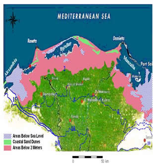 |
The most vulnerable areas of Egypt (see map) are the low-lying coastal areas of Alexandria, Behaira governorates on the West Nile delta, and the area south of Port Said – Damietta governorates. These areas are highly vulnerable to inundation from sea-level rise, which would affect water, agricultural and energy resources, as well as human settlements. The region is also highly vulnerable to the indirect impacts of erosion caused by the tidal action of the Mediterranean Sea which produces high erosion in some regions and accretion in others. The West Nile Delta is an important resource for agriculture, fishing and tourism, but suffers from severe environmental pollution and a lack of environmental monitoring and regulation. In addition, there have been significant and rapid changes along the shoreline of the North West Nile Delta since the building of the Aswan High Dam in 1964. These rapid shoreline changes can create catastrophic physical, biological and socio-economic problems. Although there is no officially endorsed national policy or national coastal zone management strategy for Egypt, considerable efforts by stakeholders have led to an agreement along the general principles of coastal zone management (CZM). The key research issues for the case study include an integrated assessment of the direct and indirect impacts of sea-level rise and salt-water intrusion, an exploration of possible adaptation options, and an evaluation of the socio-economic problems impeding sustainable development in the region.
Documents
- West Nile Delta briefing note

- Impact of Sea Level Rise on the Low Land Area South East of Alexandria, Egypt (poster)
West Nile Delta case-study indicators
Leading team
This research is coordinated by Mohamed El-Raey and Hesham El-Askary, CEDARE, Egypt