1. Climate indicators
Theme: |
Indicator name: Annual maximum temperature, 'Florence', Italy |
|---|---|
| What is it? Maximum temperature is the highest temperature recorded during a specified period of time. Anomalies are calculated as the deviation from the long-term average (1971-2000). | 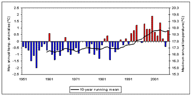 |
| What does this show? Temperatures across the region have risen by +0.3°C to +0.4°C per decade along a west-to-east gradient with a higher rate of warming inland. | |
| Why is this important? In Tuscany, temperature increase represents a hazard to the production of crops such as olive, grapevine, fruit and vegetables. | |
| Source: Grid-based dataset (E-OBS) provided by the EU project ENSEMBLES | |
Climate indicators are viewed as system 'drivers', and are presented below as two tables: indicators related to mean values of climate, and indicators related to climate extremes.
User-friendly name |
Description |
Acronym |
Maximum temperature |
Maximum air temperature for a key season relevant to the case study |
Tx |
Minimum temperature |
Minimum air temperature for a key season relevant to the case study |
Tn |
Mean temperature |
Mean air temperature for a key season relevant to the case study |
Tg |
Urban Heat Island |
Tmax and Tmin temperature difference for suitable station pairs one located within the city and one outside |
UHI |
Heating degree days |
For a key season, the sum of (mean daily temp Tg - Base temperature Tb). Units in degree days (dd). Tb = 15 deg C |
Hdd |
Cooling degree days |
For a key season, the sum of (mean daily temp Tg - Base temperature Tb). Units in degree days (dd). Tb = 25 deg C |
Cdd |
Frost days |
Annual number of frost days (Tn < 0 deg C). |
FD |
Total rainfall |
Total precipitation for a key season relevant to the case study |
R |
Relative humidity |
Relative humidity |
RH |
Evaporation from land surfaces |
Evaporation from land surfaces |
EL |
Evaporation from land and sea surfaces |
Evaporation from land and sea surfaces |
ELS |
Evapotranspiration |
Evapotranspiration (from vegetated land surfaces) |
ET |
Solar radiation |
Incident solar radiation |
SR |
Wind speed |
Mean daily wind speed. |
WS |
Ozone |
Number of days per annum that the ground level O3 concentration exceeds the EU standard concentration of 120 μg per m³ over an 8 hour averaging period. |
O3 |
Sea surface temperature |
Mean sea surface temperature (for a key season relevant to the case study) |
SST |
Storm surge |
Seasonal (key season of relevance to the case study) storm surge - the maximum increase in sea level above the astronomical tide, resulting from local and regional meteorological conditions. |
slx |
Wave height |
Significant wave height (Hs): the mean wave height (trough to crest) of the one-third largest waves, for a key season of relevance to the case study. |
Hs |
Sea level rise |
Sea level rise (relative): annual mean net increase in sea level relative to local geological adjustments. |
SLR |
User-friendly name |
Description |
Acronym |
Very hot days |
The number of events exceeding the Tmax 95th percentile |
Tx95n |
Very hot nights |
The number of events exceeding the Tmin 95th percentile |
Tn95n |
| Very cold days | The number of events falling below the Tmax 5th percentile | Tx5n |
| Very cold nights | The number of events falling below the Tmin 5th percentile | Tn5n |
Average hot day threshold |
Daily temperature mean (Tg) 95 percentile |
Tg95p |
Very hot day threshold |
Daily temperature max (Tx) 95 percentile |
Tx95p |
| heat wave | Heat Wave Duration Indicator: number of consecutive days (at least 6) with Tx > long-term Tx 95th percentile. Tx95p is calculated for a 5-day window centred on each calendar day in the common period. | HWDI |
Warm spell |
Warm Spell Duration Indicator (wsdi90): number of consecutive days (at least 6) with Tx > long-term Tx 90th percentile. Tx90p is calculated for a 5-day window centred on each calendar day in the common period. |
wsdi90 |
Heavy rainfall days |
Number of precipitation events > long-term 90th percentile of raindays |
R90n |
Heavy rainfall threshold |
90th percentile of rainday amounts (mm/day) |
R90p |
Greatest daily rainfall |
Greatest precipitation amount measured on a single day during the period of interest |
R1d |
Greatest five-day rainfall |
Greatest precipitation total falling on 5 consecutive days during the period of interest |
R5d |
Longest dry spell |
Maximum number of consecutive days with precipitation amount falling below a predefined threshold (<1mm) |
CDD |
Palmer Drought Severity Index |
An estimator of water availability, integrating information on temperature, precipitation and local available water content (AWC) of the soil |
PDSI |
The self-calibrated PDSI |
The self-calibrated PDSI adapts the PDSI to different realms of climate / land cover thereby minimising the excessive frequency of extreme events |
scPDSI |
Extreme surge frequency |
Number of events exceeding the 95th percentile of long-term daily sea level max (slx95p) |
slx95n |
Extreme surge duration |
Number of consecutive hours exceeding the long-term daily max 95th percentile (slx95p) |
sudi |
Extreme significant wave height frequency |
Number of events exceeding the long-term 95 percentile of daily sea level max significant wave height (swhx95p) |
swhx95n |
Marine storm duration |
Number of consecutive hours exceeding the long-term daily max significant wave height 95th percentile (swhx95p) |
mstdi |
Heat index |
Heat index based on Steadman (1979), and requiring inputs of dry-bulb temperature and relative humidity |
HI |