Scenarios of mean climate change over the Mediterranean |
One role of the Climatic Research Unit within MEDALUS has been to prepare scenarios of the change in mean climate over the Mediterranean Basin in response to global warming. As shown below, we found that the spatial resolution of GCMs is too coarse for direct scenario construction, and therefore we had to develop an appropriate downscaling procedure. A requirement of the downscaling method is that it should be applicable over the area of the Mediterranean Basin without too large a computing penalty.
Palutikof, J.P., Goodess, C.M. and Guo, X., 1994: Climate change, potential evapotranspiration and moisture availability in the Mediterranean Basin. International Journal of Climatology, 14, 853-869.
Palutikof, J.P. and Wigley, T.M.L., 1995: Developing climate change scenarios for the Mediterranean region. In (Jeftic, L., Pernetta, J.C. and Keckes S., eds.) Climate Change and the Mediterranean Volume 2, Edward Arnold, London, 27-56.
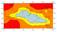
The image shows a regional scenario for annual Mediterranean temperature change, based on equilibrium GCM experiments. Here, the results from four separate models have been combined to give a 'mean prediction', since no one GCM can be shown to out-perform the others. The prediction is expressed as the change per 1 degree Celsius rise in global mean temperature.
The GCMs used to produce this scenario have a coarse spatial resolution, and this is reflected in the very simple pattern of change. For impacts analysis, however, scenarios are often required at a much finer resolution, leading to the development of 'downscaling' techniques. An example of a downscaled scenario of temperature change for the Mediterranean is given below.
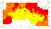
One method of downscaling combines the results from GCMs with statistical models. Taking the example of temperature, a multiple regression model is first constructed, to explain the variations in temperature at a meteorological station in terms of observed regionally-averaged climate variables such as sea level pressure and precipitation. Then, by replacing the regionally-averaged variables with GCM results, the change in temperature at the station can be estimated. If this method is applied to a dense network of stations, high resolution scenarios can be constructed. A scenario for Mediterranean annual temperature, interpolated from a network of 248 measuring stations, is shown in the image. Changes are again expressed as the change per 1 degree Celsius global warming. It can be seen that the pattern of change is more complex in this scenario, reflecting, for example, variations due to altitude and proximity to the sea.
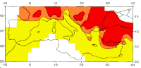
Scenarios for climate variables such as temperature and precipitation are of limited interest to impact analysts. Effects on agriculture, for example, may be better described by looking at changes in the availability of water for crop growth. We have developed an index of moisture availability, based on the ratio of rainfall (RF) to potential evapotranspiration (PET), and looked at how it may change in a future, warmer, world.
Reliable scenarios of PET cannot be developed directly from GCM output because the model treatment of ground hydrology is crude. Rather more confidence can be placed in GCM estimates of temperature, which in turn can be related to PET through empirical formulae. Using this approach, PET scenarios were constructed from sub-grid-scale temperature scenarios. Sub-grid-scale scenarios of precipitation were constructed using a network of 328 Mediterranean stations and the statistical downscaling approach described in the previous section.
For each site in the network the ratio RF/PET was calculated for the present-day and for a 1 degree Celsius increase in global mean temperature. The difference between the two ratios was then calculated and mapped. The map for winter is shown in the image. A negative change in RF/PET ratio indicates a deterioration in the water balance. The map shows an unfavourable shift in RF/PET ratio for the whole Mediterranean region. The same pattern is repeated in every season of the year.
Scenarios of this type only provide a rough guide to the implications of climate change for agriculture. They take no account of differences in soil and crop type across the Mediterranean region. However, taken with the scenarios of temperature and precipitation described earlier, they can be used to evaluate the sensitivity of the economy to future climate change.